
Home > Apps > Photography > GPS Map Camera

| App Name | GPS Map Camera |
| Category | Photography |
| Size | 22.64M |
| Latest Version | 1.4.33 |


GPS Map Camera: Enhance Your Photos with Location Data
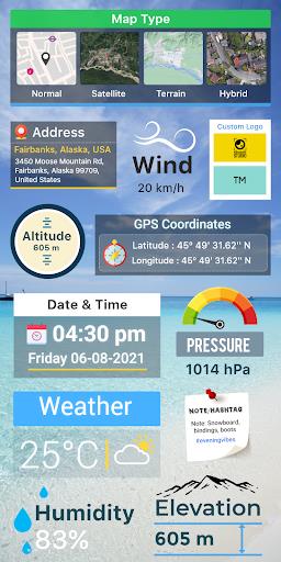
GPS Map Camera lets you effortlessly enrich your photos with precise location details, including date, time, latitude, longitude, altitude, weather conditions, magnetic field strength, and compass direction. This app seamlessly integrates live location tracking with your photography, making it ideal for documenting travel adventures or significant locations. Share your geotagged photos with friends and family, bringing them along on your journeys.
Key Features:
- Geotag Photos: Add location data (date, time, coordinates, weather, etc.) directly to your photos.
- Live Location Tracking: Track and record your location as you take pictures.
- Easy Sharing: Share your location-enhanced photos easily with loved ones.
- Customizable Camera: Enjoy features like grid lines, aspect ratios, front/selfie camera options, flash, focus control, mirroring, timer, and sound capture.
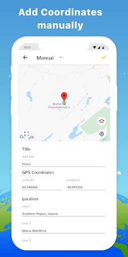
- Advanced Stamp Templates: Customize your location stamps with map types, manual/automatic location tagging, GPS coordinates, date/time stamps, logos, notes, and hashtags.
- Comprehensive Data: Access detailed information such as wind speed, humidity, pressure, altitude, and location accuracy.
In short:
GPS Map Camera is a powerful and versatile tool for travelers, businesses, bloggers, and anyone who wants to add valuable location context to their photos. Its intuitive interface and comprehensive features make it a must-have app for enhancing your photography experience. Download GPS Map Camera today and share your feedback!
-
TravelerDaveDec 20,25Pretty handy for adding location tags to my travel photos. The live location is accurate and easy to use, though I wish the weather info updated faster. Good for keeping track of where I've been! 🌍Galaxy Z Fold3
-
 Invisible Woman Debuts in Marvel Rivals Gameplay
-
 Anime Power Tycoon Embraces Lucrative Codes for Enhanced Gameplay
-
 Hades 2 Warsong Update Reintroduces Ares and Brings a New Boss
-
 Fallout-Style Game Last Home Soft Launches On Android
-
 Roblox: Free Robux via Peroxide Codes (January 2025)
-
 Squid Game: Unleashed offers immense in-game rewards for watching the show on Netflix