
Home > Apps > Productivity > ShipAtlas by Maritime Optima

| App Name | ShipAtlas by Maritime Optima |
| Category | Productivity |
| Size | 156.09M |
| Latest Version | 5.0.0 |
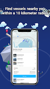
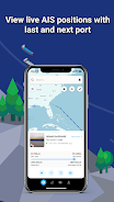


ShipAtlas, developed by Maritime Optima, is an indispensable tool for anyone involved in vessel tracking and maritime operations. Leveraging real-time AIS data from over 700 satellites and terrestrial sources, ShipAtlas provides comprehensive insights into global maritime activities. Track vessels, analyze trade patterns, monitor port activities, and gain valuable intelligence on sea routes, marine weather, ice conditions, piracy risks, and more, all within a single, powerful application. The app continuously collects and processes raw AIS data for the global merchant fleet, ensuring high-quality, reliable information is at your fingertips.
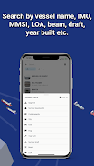
Beyond basic tracking, ShipAtlas empowers users with advanced search capabilities, allowing for precise vessel identification using names, IMO or MMSI numbers, or port details. Refine your searches further using vessel specifications like length, beam, draft, and year built. Plan voyages efficiently with the integrated sea route calculator, providing estimations for time of arrival, distance, time at sea, and even projected fuel consumption. Create and manage unlimited custom vessel lists for real-time monitoring, and stay informed with daily marine updates. The app’s intuitive interface ensures seamless navigation, while cross-device synchronization keeps your data readily accessible. Dedicated support is available via a convenient in-app chat.
Features of ShipAtlas by Maritime Optima:
- Comprehensive Maritime Intelligence: Access real-time data on port operations, sea routes, weather conditions, ice formations, piracy hotspots, and detailed marine charts.
- High-Quality Data Assurance: Rigorous data processing ensures accuracy and reliability through advanced data cleaning and validation techniques.
- Advanced Vessel Search: Locate vessels precisely using names, IMO/MMSI numbers, or port information. Utilize detailed vessel specifications for targeted searches.
- Sea Route Optimization: Quickly calculate estimated times of arrival, distances, at-sea times, and fuel consumption for planned routes.
- Customizable Vessel Tracking: Create unlimited personalized vessel lists and monitor their movements in real-time on an interactive map.
Conclusion:
ShipAtlas by Maritime Optima is a user-friendly application delivering real-time AIS data and comprehensive maritime information. Its high-quality data, intuitive interface, and powerful features, such as the sea route calculator, make it an invaluable resource for maritime professionals and enthusiasts alike. While many features are freely available, a paid subscription unlocks enhanced capabilities. Download ShipAtlas today and embark on a journey of maritime exploration and informed decision-making. Learn more on our website.
-
 Invisible Woman Debuts in Marvel Rivals Gameplay
-
 Anime Power Tycoon Embraces Lucrative Codes for Enhanced Gameplay
-
 Hades 2 Warsong Update Reintroduces Ares and Brings a New Boss
-
 Fallout-Style Game Last Home Soft Launches On Android
-
 Roblox: Free Robux via Peroxide Codes (January 2025)
-
 Squid Game: Unleashed offers immense in-game rewards for watching the show on Netflix